Menu
Menu
Menu
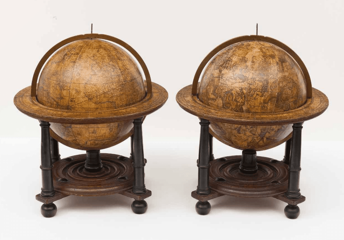
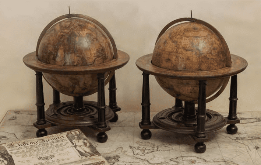
An exceptional and very rare pair of celestial and terrestrial globes
9 inch/23 cm, with an overall height of 38 cm
Amsterdam, dated 1602, but published after 1621
In their original stands with circular wooden horizon rings,
covered with printed paper, supported by four legs
and brass meridian rings supported by a single column.
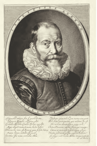
Portret Blaeu
Jeremias Falck (Danzig 1610 - 1677)
Portrait of the Dutch cartographer and globe maker Willem Jansz. Blaeu
After a painting by Thomas de Keyser, with underneath a poem by Barlaeus.
Engraving, 313 mm x 195 mm Rijksmuseum, Amsterdam inv. no.
RP-P-OB-50.564
HIS EARLY CAREER
Willem Janszoon (Jansz for short) Blaeu was the founder of a large publishing firm that became famous in the field of cartography under the name Blaeu. The Blaeus were quite a prosperous Mennonite family of Amsterdam. Willem’s father, though, lived in Alkmaar, north of Amsterdam, or in the nearby village of Uitgeest, which is where Willem was born in 1571 and where he received his early schooling.
It must have been during this period that he met Adriaan Anthonisz (1541- 1620), surveyor, astronomer, mathematician, military engineer and fortifications superintendent of the Dutch Republic. This enthusiast for the liberal arts was the father of the better-known Adriaan Metius, who was also born in 1571 and would later become Blaeu’s scientific adviser. Blaeu moved to Amsterdam at the age of 23 to learn the ins and outs of the herring trade from his family. However, being more interested in scientific matters, and especially in mathematics and astronomy, he left after two years for Denmark, where he studied for two years with the renowned astronomer Tycho Brahe (1546-1601) on the island of Hven (modern Ven in Sweden. Tycho Brahe had his own observatory, as well as a workshop for the manufacture of instruments, and a printing press. This enabled Willem Jansz to acquire both theoretical and practical knowledge, and brought him into contact with
people with similar interests.
After his return to the Netherlands he applied himself to astronomy for several years in the city of Alkmaar. Very little is known about his stay there, but it was where he married Marretie or Maertgen Cornelisdr of Uitgeest, probably in 1597. It was there, too, that his eldest son Joan was born. On 21 February 1598 Blaeu observed an eclipse of the moon from Alkmaar that was simultaneously observed by Tycho Brahe in Wandsbeck near Hamburg. The purpose of their observations was to determine the difference in longitude between the two places.
While in Alkmaar he made a celestial globe 34 cm in diameter for Adriaan Anthonisz that was based on Tycho Brahe’s new but as yet unpublished star catalogue. The globe was published in 1597/98 and was masterfully engraved by Jan Saenredam, a pupil of Hendrick Goltzius and father of Pieter Jansz Saenredam, the famous painter of church interiors.
The production of globes was Blaeu’s main activity at the start of his career, and in order to set himself apart from the many others called Willem Jansz he dubbed himself ‘Willem Jansz Globi’ or ‘Geloobmaker’. Blaeu followed the tradition of making globes in pairs: a terrestrial and a celestial one.
AMSTERDAM
Willem Jansz moved to Amsterdam with his family around 1598/99, and opened a shop selling celestial and terrestrial globes and astronomical instruments, all made by himself. The great voyages of discovery advanced the science of navigation, and there was a pressing need for astronomical instruments to determine the position of ships at sea. Blaeu had enjoyed an excellent training as an instrument maker under Tycho Brahe. He shows considerable interest in
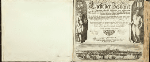
Title page ‘Licht der Zeevaart’, with the adres of W.J. Blaeu in The ‘Vergulde Sonneweyser’ Willem Janszoon Blaeu Uitgeest/ Alkmaar 1571-1638 Amsterdam Het Licht der Zee-vaert daerinne claerlijck beschreven ende afghebeeldet werde, alle de Custen ende Havenen, vande Westersche, Noordsche, Oostersche ende Middelandsche Zee’n. Amsterdam: Willem Janszoon Blaeu, 1630 In contemporary brown calf binding with 42 charts. 255 x 290mm.
Provenance:
Private collection France
Collection Rob Kattenburg
This 1630 edition is the last known foregoing Dutch edition of the Licht der Zee-vaert,
printed by Blaeu and is only known in 2 examples.
maritime instruments in his sea atlases, and illustrates or reproduces them by means of movable diagrams.
In 1605 he moved to new premises on Damrak, where most of the Amsterdam booksellers and mapmakers had clustered at that time. The building was called In de Vergulde Sonnewyser (In the Gilded Sundial) and here he also set up a printing shop and publishing house. His first publications were in the fields of cartography and navigation, and by 1608 he had already published a fine map of the world and a popular marine atlas. His early works include a globe of 1599, maps of European countries and a world map in 1604-1608.
Blaeu’s early interest in navigation led to his first pilot guide, which was called the Nieuw graetbouck. He occupies an important position in the history of early Dutch pilot guides. His famous predecessor for the description of eastern, western and northern navigation was Lucas Jansz Waghenaer. Blaeu issued two pilot guides:
Het licht der Zee-vaert (first edition 1609), which firmly established his reputation as a maritime cartographer, and Zeespiegel (first edition 1623), both of which were reprinted several times.
His reputation is apparent from a fragment of Vondel’s famous poem Lof der zeevaart (Praise of navigation) of 1623:
‘Honour is due to his [Tycho’s] pupil too, not for fancy pastry Neither for procuring marzipans, my Knights, but his Cartography, Protractors, Astrolabes, as well as Globes concave and convex, Adorned with symbols, and illustrations of wondrous effects: Who brings books to light, for which they widely render thanks, When he plumbs the grounds, and cautions against banks, The copious creeks, and corners curved and bent, By which they flaunt firmly through the fluid element.’
CARTOGRAPHY
The voyages of discovery in the fifteenth and sixteenth century created an insatiable interest in cartography. They also advanced the science of navigation, and there was a pressing need for astronomical instruments to determine the position of ships at sea. The newly discovered territories offered opportunities for trade, and it was not only essential to know how to reach them but also how to return home safely again. Knowledge increased with every voyage, and maps consequently became more and more accurate. The unfolding of new opportunities increased the demand for good maps. In addition to charts used specifically for navigation, growing numbers of people became interested in maps. They wanted to satisfy their curiosity about new countries, even if only on paper. Maps were also used to advertise one’s status, to promote a better understanding of history or politics, or to take the place of paintings.
The first large centre for the production of maps was in the southern Netherlands in the sixteenth century, with Plantin, Ortelius and Mercator as the leading publishers. They were the first printers of world atlases. Mercator’s name is indissolubly connected with his invention, the Mercator projection, a system of increasing latitudinal degrees for use at sea.
Because of Amsterdam’s growing role in international trade in the sixteenth century, it is not surprising that the market for maps and pilot guides slowly moved northwards, initially led by publishers who had emigrated to the Dutch Republic from the southern, Spanish Netherlands. Amsterdam was a favourite place for political refugees, victims of religious persecution and fortune seekers.
COMPETITION
Amsterdam expanded enormously during the Twelve Years’ Truce (1609-1621). The economy flourished and this was reflected in the output of maps. Willem Jansz was not the only publisher of maps and globes in Amsterdam. When he set up his business, Cornelis Claesz (1546/47-1609) and Jodocus Hondius the Elder (1563- 1612), both originally from the southern Netherlands, had already made a name for themselves. After Claesz’s death, Willem Jansz succeeded in acquiring much of his estate, which strengthened
his position as a map publisher. However, he had fierce competition from his neighbour Jan Jansz, or Johannes Janssonius, another mapmaker, bookseller and publisher who took the premises next door to Blaeu on Damrak. Willem Jansz had also Latinised his name to (Guilelmus) Janssonius, in accordance with the general custom, and this caused much confusion and was later abused by Jan Jansz. Willem Jansz decided to change his name and chose that of his grandfather, ‘Blauwe Willem’ (Blue William) as his surname in 1621. From then on, he called himself Willem (Jansz) Blaeu and sometimes added the Latinised form ‘Caesius’ (bluish-grey) to his imprints.
In 1621 Janssonius published a plagiarised copy of Blaeu’s pilot guide Het licht der Zee-vaert. He was able to do so with impunity because Blaeu’s copyright had expired. Blaeu then decided to compete with his competitor Janssonius and his brother-in-law Henricus Hondius(1597 - 1651) in the field of atlas production, in which the latter had a monopoly with the Mercator/Hondius/ Janssonius atlases. Blaeu had already published several maps in atlas format and started to gather maps for his own atlas. In 1630 he purchased 37 plates of the Mercator atlas from Jodocus Hondius the Younger. He added these to his own collection and published the Atlantis appendix, which contained 60 maps. This publication sparked off a new trend in Amsterdam atlas production that was characterised by competition and an increased output of maps. Blaeu then began planning a major atlas that would include the most up-to-date maps of the entire world.
In 1633, partly due to aggressive competition from the firm of Hondius-Janssonius, Blaeu announced his intention to publish a new Theatrum orbis terrarum, sive, Atlas novus in two volumes. According to Gunter Schilder, correspondence between Blaeu and Wilhelm Schickhard indicates that Blaeu intended to complete the atlas that same year. Blaeu’s plan for a new ‘International edition’ of a world atlas was publicised in an Amsterdam newspaper on 11 February 1634. ‘Presently being printed at Amsterdam by Willem Jansz Blaeu is a large book of maps, the Atlas, in four languages: Latin, French, German and Dutch. That in German will appear around Easter, those in Dutch and French in the month of May, or early June at the latest, and the one in Latin shortly thereafter. All editions on very fine paper, completely renewed with newly engraved copper plates and new, comprehensive descriptions.’ Despite the fact that the newspaper announcement in early 1634 stated that the atlas was ‘presently being printed’, only the German edition was completed that year, though not in its final form. In 1635 Blaeu issued the first two volumes of the Atlas novus. Progress was painfully slow, and although he spent the rest of his life compiling maps for this ambitious project, the atlas was not finally completed until well after his death.
MAPS
Willem Blaeu’s wall maps are considered to be among the most influential and artistically virtuosic masterpieces of the great age of Baroque cartography. The publication of his first set of wall maps in 1608 marked the start of his ascendancy to the pre-eminent position he occupied in the highly competitive worldwide map
market. Blaeu published several wall maps, printed on parchment or paper. A fine example of one on vellum is this PASCAARTE van alle de Zécuften van EUROPA. Nieulycx befchreven door Willem Ianß. Blauw. Men vintfe te coop tot AMSTERDAM, Op’t Water inde vergulde Sonnewÿser.
It was first published some time between 1621 and 1650. It is the first state of two, and measures 687 x 868 mm. The title and imprint are in a cartouche crowned with Willem Jansz Blaeu’s printer’s mark, with his ‘INDEFESSVS AGENDO’ motto at the centre of the lower border. The map is very rare, and surprisingly no Dutch institution has an example on vellum. Interestingly, Johannes Vermeer used this map in his painting The Geographer of 1669), which is now in the Städel Museum in Frankfurt. Amsterdam was the world centre of mapmaking in Vermeer’s day, and Blaeu’s wall maps were among its most majestic productions.
Blaeu also printed loose track charts on parchment, known as ‘overzeilers’ in Dutch (literally ‘charts for sailing across oceans and
Willem Jansz. Blaeu
Uitgeest / Alkmaar 1571 – 1638 Amsterdam
Sea Chart of all the Seacoasts of Europe, c. 1625
Copper engraving and etching on vellum, handcoloured, 68.7 x 86.8 cm
First state ot two, 10 other documented copies
(all on vellum except 1)
Scale: c. 1:7.500.000
In cartouche: PASCAARTE van alle de Zècusten
van EUROPA / Nieulycx beschreven door
Willem Janß. Blauw / Men vintse te coop tot
AMSTERDAM, op ‘t Water inde vergulde
Sonnewijser
Provenance:
France, collection of a noble family
Collection Rob Kattenburg
seas’) which were printed on an especially wide press. In addition to charts, Blaeu issued several folio maps, as well as assembled wall maps and a series of large-format profiles of cities throughout the world, many of them with figural borders.
THE BLAEU FAMILY
The production of globes was also an important and lucrative part of the business. In the second half of the seventeenth century, after buying up the copper plates of all the rival firms, the Blaeus became the sole producers of globes in Amsterdam. In addition to his activities as a publisher, Blaeu continued his scientific pursuits. He used his findings to improve his maps and guides, so each discipline strengthened the other. His expertise won official recognition when he was appointed official cartographer and examiner of navigating officers to the Amsterdam chamber of the Dutch East India Company (VOC) in 1633. It was a period when Amsterdam was one of the wealthiest trading cities in Europe, and a centre for banking and the diamond trade. The VOC (1602-1798) contributed significantly to the wealth and prosperity of the Dutch Republic, and Blaeu’s prestigious appointment firmly established his reputation within the highly competitive world of Dutch mapmakers. As official cartographer of the VOC, as well as of the Dutch West India Company (WIC; 1621-1792), Blaeu had the finest craftsmen at his disposal, and the quality of his own work continued to improve. The artists drawing and colouring the maps usually worked on the premises, which meant that the quality of their work was under constant
supervision.
Willem Jansz Blaeu sold his products not only in Amsterdam but throughout Europe. One key plank in his merchandising strategy was the biannual Frankfurt Buchmesse, where book and print publishers and sellers from all over Europe gathered to display and sell their latest wares.
Blaeu published a new edition of his world atlas in German (10 March 1634), Latin (13 April 1635), Dutch (22 April 1635) and French (1 July 1635). He had ambitious plans for his publications, and said in the preface to the German edition of 1636: ‘Our intention is to describe the entire world, that is the heavens and the earth, in several volumes like these two, of which two more of the earth will shortly follow’. But Blaeu did not live to see the publication of the other two volumes he had prepared. They appeared in 1640 (Italy) and 1645 (England).
After his death in 1638, Willem Jansz was succeeded by his sons Joan (1598/99-1673) and Cornelius (c. 1610-1642) Blaeu, who continued and expanded their father’s ambitious plans. Joan inherited his father’s VOC duties, which included making manuscript charts and compiling sailing directions for navigators. He had access to a vast amount of up-to-date information, particularly about parts of the world dominated by the Dutch. Although much of this information was incorporated into his manuscript charts and large wall maps, it seems he was unable to take advantage of his privileged position with the VOC for his own publications, with the result that many of the maps in his great atlases contain less accurate information than that of his competitors.
Joan continued the business alone after Cornelis’s death in 1644, and established his own reputation as a great mapmaker. He completed his father’s grand project in 1655 with the sixth and final volume of the Atlas novus. Joan succeeded in producing the most voluminous world atlas of all time when the magnificent Atlas
maior saw the light of day in 1662. The final, eleventh volume of the Spanish edition was in the press when, on 28 February 1672, the printing shop was destroyed by fire, a blow from which the famous Blaeu publishing house never recovered. Joan’s sons Johan and Peter were the third generation to run the firm before it closed down in 1706. The printing shop had already been sold in 1695.
Blaeu’s terrestrial globes were highly valued and much in demand, due the care with which they were prepared and because of the efforts to provide up-to-date information about the latest discoveries. They were the most advanced cartographic documents of the day.
The geographical details in the seas and oceans are engraved and include loxodromes for the 32 compass points. These loxodromic lines made them valuable to navigators. In addition, they represented the curves of the wind directions.
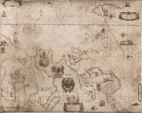
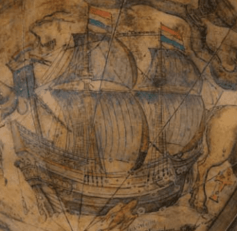
Willem Jansz Blaeu collected information that Dutch mariners gathered from around world and brought back to Amsterdam. Crews were instructed to record information about the lands they visited and the skies they saw. Blaeu incorporated these observations in maps and globes. Through his web of contacts and thanks to assiduous research he was also able to obtain the most recent information about the latest discoveries in the western hemisphere and the South Pacific, where Dutch explorers were particularly active at the time. Since the globe was published after 1618, Blaeu was able to include the discoveries made by Henry Hudson in his attempt to find a passage to the East Indies. He also included recent Pacific discoveries of the celebrated voyages of Willem Cornelis Schouten and Jacob Le Maire, who both traversed the South Pacific and the Atlantic. The findings of Schouten and Le Maire in the Tierra del Fuego region are also incorporated.
The Strait of Le Maire is drawn and the hypothetical southern continent is labelled ‘TERRA AUSTRALIS INCOGNITA MAGALANICA’. Olivier van Noort’s track is drawn and labelled. His route is indicated with a broken line and the words: ‘Navigationis Olivierij ductus’ (several times). There are various decorative features, such as animals on the different continents, many ships on the high seas, and allegorical and mythical figures around the cartouches.
The 9-inch globe is not just a smaller version of the one published in 1599. Drawings of animals and people do often correspond to those on the earlier globe, but Blaeu made several significant changes:
- The west coast of North America is drawn differently and the river system of Brazil is altered.
- The hypothetical southern continent is labelled: TERRA AUSTRALIS INCOGNITA MAGALLANICA.
- There are nine ocean names in handsome curling letters: Mare Congelatum, Mare Atlanticum, Oceanus Aethiopicus, Mare Arabicum et Indicum, Mare di India, Oceanus Chinensis, Mar del Zur, Mare Pacificum, Mar del Nort.
- Willem Blaeu, always eager to display the latest discoveries, traced the route of Van Noort’s route with a broken line. The findings of the voyage of Schouten and Le Maire in the Tierro del Fuego region are included, despite the 1602 date (names: Fr. Le Maire, Mauritius, Staten Landt, C.Hoorn, I.Barneveltij).
TECHNICAL DETAILS
The diameter of the terrestrial globe is 23 cm (9 inches) and the overall dimensions are 38 cm high and 33.5 cm wide. The globe is dated 1602 but was published after 1621, since it includes the discoveries of Schouten and Le Maire. The globe has 12 full, copper engraved, hand-coloured (with gold heightening) and varnished gores running from the north to the south equatorial pole. The sphere is mounted in a graduated brass meridian ring (clockwise from N: 0° - 90°; 90° - 0°; 90°- 0°; 0°- 90 °; numbered every 10°, with 1° divisions). The meridian ring is signed with the production number ‘4’. There are five cartouches, four of them in the southern continent and one in North America. Loxodromes for 32 points of the compass are drawn in the seas and oceans. The horizon ring is copper-engraved on paper and has a surface coating.
Scales (from inside to outside): for the zodiac (12 times 0° - 30°; numbered every 10°, with 1° divisions), with the Latin names and the symbols of the signs of the zodiac; for the Gregorian calendar labelled: Calendarium antiquum commune (numbered every 10 days, with 1 day divisions) with the Latin names of the months; and for the twelve wind directions with names in Greek and Latin, and twelve compass points with names in Dutch. The zodiac starts at the Julian calendar scale 10. 25 days after the beginning of March,
Detail of the 9 inch terrestrial globe
that is, the first point of Aries is at 11 March 6 hours; with respect to the Gregorian calendar the first point of Aries is at 21 March 6 hours.
CARTOGRAPHY
Latin. Co-ordinates: meridians every 10°. Parallels every 10°. The prime meridian runs west of the Azores (through Corvo or Flores). The equator is graduated (0° - 360°; numbered every 10°, with 1° divisions) and labelled CIRCULUS AEQUINOCTIALIS. The ecliptic is graduated (12 times 0° - 30°; numbered every 10°, with 1° divisions) and provided with the symbols and signs of the zodiac. The vernal equinox is at L 0°. There is a latitude scale along the prime meridian (N & S 0° - 90°; numbered every 10°, with 1° divisions). There are labels for the Circulus Arcticus, the Tropicus Cancri, the Tropicus Capricorni and the Circulus Antarcticus.
GEOGRAPHICAL NOTES
There are loxodromes for 32 compass points. The Strait of Le Maire is indicated and the hypothetical southern continent is labelled: TERRA AUSTRALIS INCOGNITA MAGALANICA. Olivier van Noort’s track is drawn and labelled Navigationes Olivierij ductus, Exitus Olivierij and reditus Olivierij.
CARTOUCHES
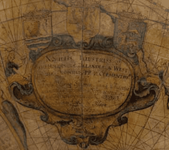
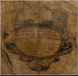
The globe is decorated with five cartouches, four of them in the southern hemisphere and one in North America. The oval dedication cartouche is in the hypothetical southern continent (L 180° - 240°, 20° - 60°) and topped with the coats of arms of Holland, Zeeland and West Friesland. There are several figures on the left, right and bottom, among them a woman pouring water into a scale and Justitia with a sword and the scales of Justice.
The text reads:
NOBILISS: IS ILLUSTRIS: IS-Q(UE) | D.D. [Dominis] HOLLANDIAE, ZELANDIAE, AC WEST: | PHRISIAE ORDINIBUS PP: P: [= Patribus Patriae] CLEMENTISS. IS | Hanc| Terrae Marisq(ue) Sphaeram, summâ diligentiâ | accuratissime fabricatam; Debiti honoris gra: | tiq(ue) animi testimonium, L[ibens] M[erito] D[at] D[icat] D[edicat] Guilielmus Janssonius Blaeu | Anno 1602.
(To the most noble and illustrious Lords, the States of Holland, Zealand and West Friesland, the most clement Fathers of the Fatherland, this globe of the land and the sea, constructed most accurately with the utmost diligence, is given, consecrated and dedicated willingly and rightly as a testimony of due honour and a thankful heart, by Willem Jansz Blaeu, in the year 1602.)
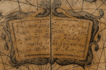
The Notice to the reader is in an oval cartouche with angels on either side and a cherub holding a vertical sundial at the top. It is placed in the hypothetical southern continent at L 120 °- 180°, S 20 ° - 70°. It contains the following Latin inscription:
En denuo, Geographiae | studiose, terrestrem contrac: | tiori formâ globum; multo, | quam antehac unquam, | emendatius et auctius confec: | tum; et ventorum spiris navi: | gantium co(m)modo exquisitius | adornatum; nec non navi: |gationis curriculo, ab Oli | verio van noort Batavo, | in orbem peracto, notatu(m) | Auctiore Guilielmo Jansonio Blaeu.
(Once again, lover of geography, a terrestrial globe in reduced form, emended and augmented much more thoroughly than before, and for the sake of seafarers, exquisitely adorned with the wind spirals [loxodromes], and with the depiction of the route that the Dutchman Olivier van Noort followed around the world. Willem Jansz Blaeu. Anno 1602).
Olivier van Noort, the Dutch navigator mentioned in the cartouche, embarked on his journey in 1598. He crossed the Strait of Magellan to travel to the Dutch East Indies and then went to Cape Town. He returned to Rotterdam on 26 August 1601. Van Noort was the first Dutchman to circumnavigate the world.
Inscribed in the cartouche on the hypothetical southern continent, below the Cape of Good Hope, at L 40° - 80°, N 45° - 6O°, with two mermaids:
Africanum bonae Spei promontorium | primus Vasco de Gama superavit; | navigatione illa quae mandato | Emanuelis primi, Lusitanorum | Regis, instituta est. Anno 1497.
(Vasco da Gama conquered the African Cape of Good Hope, during the voyage begun under the command of Emanuel I, King of the Portuguese, in the year 1497.)
Detail of the 9 inch terrestrial Globe
A simple oval cartouche, placed in the southern continent, southeast of Tierra del Fuego, mentions Magellan’s discovery: Magallanicu(m) fretum a Magellano qui | illud an(n)o 1519 primus pervium [invenst] nome(n) | sortitum est: postea ab Anglis quidem lustratu(m) | sed nunc demum pleniori cognitione ab | Olivierio van noort Batavo illus: | tratum Anno 1600.
(The Strait of Magellan was named after Magellan, who was the first to find a way through here in 1519. It was later passed by the English, but has now at last been made known through a fuller examination by Olivier van Noort, the Dutchman, in the year 1600.)
The text of the two cartouches placed at the bottom of Africa and at the bottom of America are partially erased. That of the cartouche placed in North America, speaking of the discovery of America by Christopher Columbus in 1492, is totally illegible.
Detail of the 9 inch celestial Globe
A celestial globe is a sphere on which a map of the heavens is drawn, engraved or pasted. Because it is a model of the firmament as seen from an external point, rather than from a geocentric point, the constellation figures were traditionally represented from the back, as if they turned their faces to the earth.
Celestial globes were used to represent the constellations without the distortions found on flat maps. They enabled graphical solutions to some basic problems of positional astronomy, for example, the relationship of the stars to the horizon, meridian, or ecliptic at a given time.
The earliest extant celestial globe is that borne on the shoulders of The Farnese Atlas, a Roman statue currently preserved in the Naples National Archeological Museum. It is the oldest surviving pictorial record of western constellations, but has long been presumed to represent constellations mapped in earlier Greek work. It
dates to Roman times, around AD 150, and is a Roman copy of a Hellenistic sculpture of a man kneeling with the celestial spheres, not a globe, weighing heavily on his shoulders. Eudoxus of Cnidus owned and described a globe more than five centuries earlier.
In the Almagest, an astronomical guide written around AD 150 by Ptolemy (c. AD 100 - c. 170) offered advice on the making of a celestial globe. He recommended a dark background with yellow stars of a size commensurate with their stellar magnitude. In contrast to the style of Eudoxus of Cnidus (c. 408.- 355 BC) and
his followers, Ptolemy drew his constellation figures dimly so not to detract from the stars. The Almagest served as the basic guide for Islamic and European astronomers until about the seventeenth century.
Celestial globes were made at a very early date in the Islamic world, and arrived in Europe through Arabic channels in the middle ages. China had its own tradition of celestial globe production that dated back to about the fifth century AD.
A number of celestial globes were made from the sixteenth to the eighteenth centuries, some by people who were also famed for their exceptional maps. Apart from the early production centre in Nuremberg there was the famous mapmaker Gerard Mercator (1512-1594). In 1555 he made the largest astronomical gores that
had been seen until then, and this influenced several subsequent planispheres and globes. Like their terrestrial counterparts, the celestial gores were consecutive segments whose images were produced on a woodblock or copperplate and then printed. Typically, there were a total of 12 gores (or 24 half gores), each representing 30 degrees of celestial longitude.
The first maker of globes from the northern Netherlands was the cartographer Jacob Floris van Langren (before 1525-1610). He published his first terrestrial and celestial globes in 1586 with a diameter of 32.5 cm, the terrestrial globes being based on the work of Mercator. The second edition of the celestial globe was improved
after the observations of the southern hemisphere by Pieter Dirkz Keyser and Frederik de Houtman were incorporated by the geographer Petrus Plancius (1552- 1622), who was also influential as a globe maker. Two other famous Dutch mapmakers produced celestial globes: Jodocus Hondius the Elder (1563-1612), one of the most notable engravers of his day, and Willem Jansz Blaeu (1571-1638).
CELESTIAL GLOBES BY WILLEM JANSZ BLAEU
Willem Janszoon (Jansz for short) Blaeu became interested in mathematics and astronomy at an early age, and showed such promise that he was accepted as a pupil by Tycho Brahe, the greatest astronomer of his day, and went to study at Brahe’s observatory on the island of Hven, Denmark (modern Ven in Sweden).
In the winter of 1596/97 he made his own observations of the skies. When he returned to the Netherlands he made his first celestial globe, 34 cm in diameter, based on Brahe’s new but as yet unpublished star catalogue. This globe was published in 1597/98 and was masterfully engraved by Jan Saenredam.
It records the early seventeenth-century knowledge of the skies, including recently discovered stars. The fixed stars are placed according to the observations of Tycho Brahe.
In addition to the traditional constellations attributed to Ptolemy there are others that had been discovered more recently in the southern hemisphere as a result of Dutch exploration in the East
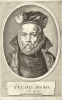
Jeremias Falck (Danzig 1610 – 1677)
Portrait of the Danish astronomer Tycho
Brahe (1546-1601) 1644
Engraving, 309 - 193 mm
Rijksmuseum, Amsterdam inv. no.
RP-P-OB-50.565
Indies, principally by the Dutch explorer Cornelis de Houtman. He also included several non-Ptolemaic constellations along with the 12 southern constellations of Plancius, which were based on the observations of Cornelis’s brother Frederik. They consist of 300 positions of the southern constellations measured by the latter.
With their wealth of astronomical information, Blaeu’s celestial globes demonstrate his great interest in astronomy.
At the beginning of his career Blaeu focused mainly on the production of celestial and terrestrial globes. His later celestial globes followed Saenredam’s style.
THIS 9-INCH CELESTIAL GLOBE
This celestial globe was made by Blaeu, whose signature, Auctore Guilielmo Janss. Blaeu, is engraved in the sphere. It was made in Amsterdam in 1602, but not published until after 1621. It is 9 inches (23 cm) in diameter, and has the same construction as the terrestrial globe. In order to spin on its axis, the sphere was held
in a meridian ring, which was adjustable for the user’s latitude within the original wooden stand. The top of the stand served as the horizon circle, and a printed calendar and wind rose are pasted onto it. Near the north pole of the meridian ring, used to be an hour circle, the pointer of which turned as the globe revolved.
The celestial globe is covered with 12 full ecliptical gores from the south to the north ecliptic poles. The gores are copper engraved, hand-coloured (stars in gold), and varnished. The overall dimensions of the globe are 38 cm in height and 33.5 cm in width. The number ‘12’ is stamped on the meridian ring. The celestial sphere is an external projection of the epoch of 1600.The astronomical content combined with the new drawing style made this celestial globe the best and most modern of its time.
The cartography on the globe is in Latin, and the coordinates have circles of latitude every 30° (gore edges). The celestial globe is decorated with the symbols and signs of the zodiac. The equator is graduated [0° - 360°; numbered every 10°, with 1° divisions]. There are labels for the Circulus Arcticus, the Tropicus Cancri, the Tropic(us) Capricorni, the Polus Antarticus, the Polus Eclipti[cae], Borealis, the Polus Eclipticae Borealis, the Colorus Aequinoc[ialis] and the Colorus Solstitiorum.
There is a cartouche crowned by the coats of arms of Zealand, Holland and Friesland to the right of Cassiopeia at RA 50° - 80°, N 50° - 80°, with a dedication similar to the one on the terrestrial globe: ‘Nobilissis Illustrissis DD Hollandiæ Zelandiæ et Westfrisiæ ordinibus DD: suis Clementissis hunc astriferum inerrantium stellarum globum summa cura et industria adornatum, debiti obsequi et gratitudinis DDD Guilielmus Janssonius Blaeu 1602]’ (the date is legible but part of the bracketed text is not). (To the most noble and illustrious Lords, the States of Holland, Zeeland and West Friesland, the most clement: this celestial globe of the fixed stars, prepared with great care and diligence, dedicated by Willem Jansz Blaeu in testimony of his obedience and gratitude 1602).
As on the terrestrial globe, the dedication cartouche is surmounted by the coats of arms of the three provinces mentioned. It is placed between the constellations of the Plough and Cassiopeia.
The Notice to the reader is in a cartouche to the right of the constellation of Auriga: [RA 90° - 120°, N 30° - 60°]. It contains the following Latin inscription: Habes hîc Astrophile, | stellarum inerrantium ex | certissis [is] D [omini] Tych: Brahe (mei | quo(n)dam præceptoris) obser- |vationib(us), numero & disposi: | tione prae aliis, a(n)no 1600. ac- |comodatarum Sphæram | accuratissime expolitam ; et | Australibus asterismis quod | novum | à Frederico Hout: |ma(n)no
observatis exornatam | Auctore Guilielmo Janss[o] Blaeu (Here, astrophile, you have a very accurate and carefully corrected globe of the fixed stars, following the faithful observations of the noble Tycho Brahe (at one time my teacher). Better adapted than others for the year 1600 as regards their number and position, and what is new, adorned with the southern stars as recently observed by Frederik de Houtman, By Willem Jansz Blaeu).
ASTRONOMY
The number and arrangement of the stars of the globe follow the most accurate observations of Tycho Brahe, Blaeu’s teacher, with added comments adjusted in 1600, and supplemented by a representation of the constellations of the southern hemisphere recently discovered by Frederik de Houtman, Dutch explorer and astronomer.
An example of three gores with dedication
and incomplete text of a celestial globe by
Willen Jansz Blaeu.
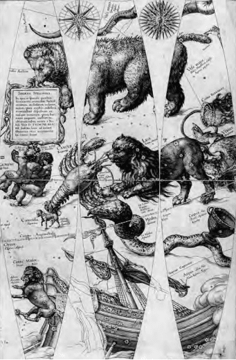
A figure or a sign represents the stars of between the first and sixth magnitude, while nebulae have their own representation. The beautiful constellations, drawn in the style of the Dutch painter Pieter Jansz Saenredam, all have Latin names. There are 48 constellations by Ptolemy. Blaeu added 10 in the southern hemisphere, including Coma Berenices and Antinous, the names they bore in antiquity. The legend in the constellation of Cepheus refers to one of its stars: ‘Haec stupendæ magnitudinis stella insolito fulgore anno 1572 in Cassiopeia sede amicuit’
In the constellation of Cygnus, there is a label that reads: Nova Stella | anni 1600, and Novam illam Stellam (quae | anno 1600. primum in pectore | Cygny apparuit, atque etiamnunc | immota manet) ex diligenti nostra | ad caudae lyraeque lucidas observatione | Longit: [sign Aquarii] 16 °15’, Latit: B: 55 ° 30’ | habere comperimus
(We calculated that this new star (appearing for the first time in the year 1600 in the breast of Cygnus and continuing unaltered until now) according to our diligent observations at the lights in the Tail and in Lyra has a longitude of 16°15’ in Aquarius and a latitude of 55°30’ north).
It is on this globe that the nova in the northern constellation of Cygnus was recorded for the first time, and was observed by Blaeu himself in 1600. To summarise: depicted on the celestial globe are 48 Ptolemaic constellations and the non-Ptolemaic constellations of Coma Berenices, Antinous, Cruzero, Columba Noë. Plancius’s 12
southern constellations are also included. Van der Krogt lists this celestial globe in its second and final state in his Globi Neerlandici (BLA III, pp. 501-502).
NOTES
Van de Krogt (1993), state 2. The data for the 12 southern constellations depicted on this globe were copied from those on Hondius globes, regardless of Blaeu’s claim that they were observed by Frederik de Houtman. The latter’s observations appeared for the first time on Blaeu’s globe of 1603 (see p. 285). Blaeu’s 1602 globe is the first public record of the nova in Cygnus, based on observations by Blaeu himself.
Detail of the celestial 9 inch globe
The belief that medieval man thought that the world was as flat as a pancake and that if a ship sailed far enough out to sea it would fall over the edge is a myth that did not take shape until the nineteenth century. The fact that globes depicting the heavens and the earth were being made back in antiquity is something that is known from written sources.
The production of globes did not, however, really take off until the era of the major voyages of discovery. It evolved rapidly during the European Renaissance as a result of technological developments such as printing, and the availability of Latin translations of Ptolemy’s treatise Geographica in the early fifteenth century. The
earlier Islamic tradition of globe making focused mainly on the celestial globe, but Ptolemy’s work and new discoveries made by European voyagers provided the stimulus to develop the terrestrial globe as a scientific instrument. By the end of the fifteenth century globe making had become a well-established craft in Europe.
Nuremberg was the first European centre of globe production. It was there, in the 1520s, that Johann Schöner founded the first workshop for the mass production of globes from printed gores. Another Nuremberg globe maker was Georg Hartmann. In 1537, in Louvain, Gemma Frisius issued a celestial globe with gores engraved by his pupil, Gerard Mercator. Mercator published his own celestial globe in 1551, and set standards for other makers to follow.
By the late sixteenth century it had become customary to carry globes on board ships because of their importance for accurate navigation.
Amsterdam was by now the most important centre for the production and international distribution of globes. Principal makers included Jodocus Hondius, Willem Jansz Blaeu and members of their families. Hondius and Blaeu made use of the southern constellations observed by Pieter Dircksz Keyser and Frederik de Houtman on recent Dutch voyages around the Cape of Good Hope. Blaeu had previously studied with Tycho Brahe at Hven and incorporated Tycho’s observations in his celestial globes.
There were makers of globes in various West European countries, but the Netherlands dominated production throughout the seventeenth century. This is actually no surprise, since the Republic
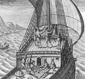
Title page of: Thomas Hood. T’ghebruyck van de Zeecaerte (1602)
View of a ship’s deck with a marine astrolabe and globe. Sailors are working on a chart
with pair of compasses and a ruler. Another sailor is on the foredeck measuring height
with a cross staff (Jacob’s staff). To his right is a man holding a quadrant.
Provenance:
Collection Rob Kattenburg
>>
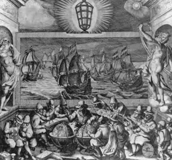
Title page from ‘Het Licht der Zee-vaert’
In the centre, a celestial and terrestrial globe can be seen.
Petrus Plancius is explaining the terrestrial globe.
Plancius (1552 – 1622) was a minister of religion in Amsterdam but, in addition,
an extremely important geographer and the VOC’s first map-maker (1602-1608).
Provenance:
Collection Rob Kattenburg
had become Europe’s greatest seafaring nation, which naturally bolstered the demand for globes. In addition, cartographers and astronomers continued to make new discoveries, which meant that the globes had to be updated. Cartographers, engravers, carpenters and the actual globe makers collaborated in the creation of the
globes. From their very inception, globes were expensive, so they were treated with care, and it is only due to their great fragility that so few having survived from that period. Most of the globes currently available to the trade are nineteenth or even twentieth-century copies that can in no way compete with the beautiful globes of the seventeenth century.
Globes have throughout the centuries served as ‘models or analogies to nature for the ‘edification of man’ and as such acted as ‘bridges between natural science and popular culture’. In this process they were often regarded as symbols of science in the arts.
THE MAKING OF GLOBES
Before 1680 there was actually no written manual for making globes. The skill was learned by practice. The manufacturing process was of great complexity. The most difficult part was the spherical form. A semi-spherical mould made of wood or metal was coated in fat or oil and then covered with many layers of papier-mâché. The
trick was to keep the outer surface as smooth as possible. When the halves were ready, a wooden axis was fitted and the halves were brought together. Inevitably, the weight would not be distributed evenly, leaving the globe imbalanced. The process of balancing it involved gluing small packages of lead shot in cloth on the inside of the globe to prevent it from slumping into one position.
The sphere now had its definitive shape and a final layer of plaster ensured the required smooth surface to which the segments of the chart were applied. This was an extremely painstaking and time-consuming process, because the long strips of the chart had to fit together to the nearest millimetre. Once the chart had been entirely or partially coloured, a layer of varnish was applied to protect it. A single central column supported the meridian ring around the globe.
THE OUTPUT OF THE BLAEU WORKSHOP
In 1597 or 1598, Willem Blaeu began by drawing a celestial globe 34 cm in diameter after observing the stars while spending a winter with Tycho Brahe in Denmark. In 1599, after two years of study with the renowned Danish astronomer, he moved to Alkmaar and produced a celestial globe 34 cm in diameter. Shortly after this he published an accompanying terrestrial globe, for which he claimed originality of geographical routes.
Driven by financial necessity, he hastened in 1602 to produce smaller globes, such as this one, which is 23 cm in diameter.
The manufacturing process of globes was very expensive and of great complexity. The sphere was made of paper mâché and then covered with a plaster coating on which the gores and polar calottes were pasted.
Each hemisphere of a globe is covered with 12 gores - triangular pieces of material (fabric or paper), paper in this particular case. Each gore extends from a pole to the equator, so the total number of gores on each globe is two times twelve, or 24. The gores are copper engraved, hand-coloured and with gold applied for the stars, and varnished. The sphere is mounted in a graduated brass meridian ring.
Willem Blaeu globes were very popular indeed, but they were only available to wealthy clients like merchants, scientists and collectors. They were also used for navigational and educational purposes by the admiralties, the West India Company (WIC) and the East India Company (VOC), amongst others. These 23-cm globes enabled Blaeu to attract a wider clientele. In 1606, he published even smaller ones, just 13.5 cm in diameter. He also published large wall maps.
This intense activity allowed him to obtain a patent (privilege) from the States-General in 1608. In 1614, to wrest the advantage from his competitor Hondius, Blaeu began on the construction of a 68 cm diameter globe, which he published in 1616. It then remained in production for almost a hundred years.
Willem Jansz. Blaeu is regarded as the greatest globe maker of his age. Most globes in public institutions today were made by him.
After Willem’s death, his son Joan Blaeu (c. 1598-1673) took over the publishing firm and continued to produce his father’s globes. The successive acquisition of the copper plates of competing globe making firms in Amsterdam (those of the Hondius family in particular) gave Joan a monopoly in by the middle of the seventeenth century.
The Blaeu firm was bought in 1682 by Jan Jansz van Ceulen (1635-1689), who purchased all the copper plates and tools from the heirs. In 1682 he requested and received a charter for the sole production of globes in Holland for the next 15 years. Van Ceulen published a 34-cm globe bearing his signature that is dated 1682.
After his death in 1689 his estate was bought at auction by Johannes de Ram. The last known editions of Blaeu’s globes (26 inches) were produced by Jacques de la Feuille, who had married De Ram’s widow.
SELECTED BIBLIOGRAPHY
- Blaev, I. Tweevovdigh onderwiis van de hemelsche en aerdsche globen;: het een na de meyning van Ptolemevs met een vasten aerdkloot; het ander na de natuerlijcke stelling van N. Copernicvs met een loopenden aerdkloot, 2 vols., Amsterdam (ter drukkerye van Ioan Blaev) 1647, vol. 1.
- Dekker, E. Globes at Greenwich: a Catalogue of the Globes and Armillary Spheres in the National Maritime Museum, Greenwich, Oxford & Greenwich 1999.
- Dekker, E. and P. van de Krogt, Globes from the Western World, London 1993.
- Kanas, N. Star Maps, History, Artistry and Cartography, 2nd edition, New York, 2009.
- Keuning, J. Willem Jansz. Blaeu : A Biography and History of his Work as a Cartographer and Publisher, revised and edited by Marijke Donkersloot.
- Koeman: Atlantes Neerlandici, vols. 2 and 4.
- Krogt, P van der. Globi Neerlandici, the Production of Globes in the Low Countries, Utrecht 1993.
- Krogt, P. van der. Old Globes in the Netherlands, Utrecht 1984.
- Lankford, J. History of Astronomy. An Encyclopedia. New York, 2001.
- Mosley, A. Bearing the Heavens. Tycho Brahe and the Astronomical Community of the late Sixteenth Century, Cambridge 1997.
- Pelletier, M. Cartographie de la France et du monde de la Renaissance au Siècle des Lumières, ‘ Les Globes dans les collections françaises aux XVIIe et XVIIIe siècles’, Paris 2001.
- Stevenson, E. L. Terrestrial and Celestial Globes, New Haven 1921, Vol. 2.
- Idem, Willem Janszoon Blaeu, a Sketch of his Life and Work, New York 1914.
- Schilder, G. Monumenta Cartographica Neerlandica, vol. 3, Alphen a/d Rijn, 1987.
- Wildeman, D. De Wereld in het klein. Stichting Nederlands Scheepvaartmuseum, 2006.
ACKNOWLEDGEMENTS
Production and research Rob Kattenburg
Text Saskia Kattenburg
Rob Kattenburg
Translation Michael Hoyle
DTP & Printing Die Keure, Bruges
Photography Margareta Svensson, Amsterdam
Published by Rob Kattenburg BV, 2017
Eeuwigelaan 6
1861 CM Bergen (NH)
The Netherlands
Tel. +31 (0)72 589 50 51
Fax +31 (0)72 581 6031
[email protected]
www.robkattenburg.nl
By appointment only
The terrestrial and celestial globes are 9 inches (23 centimetres) in diameter, with an overall height of 38 cm. Each globe is made of paper-mâché covered with a thin coating of plaster. They are cast around a wooden spindle running between two poles.
The sphere is made up of a set of 12 full engraved gores. The gores are copper engraved, hand-coloured (with gold heightening) and varnished. Each sphere is mounted in a graduated brass meridian ring, with punched numbers every 10°. The meridian ring of the terrestrial globe has a production number ‘4’ stamped on the back. The celestial globe has a production number ‘12’, since Blaeu used different production numbers for each globe. The hour circles are missing, as usual.
The globes are mounted on their original four-legged, ebonied oak, Dutch stands, which support the wooden horizon ring. The latter is covered with copper-engraved paper and has a varnished surface coating. The legs are connected by two crossbeams that support a circular baseplate with a central support for the meridian ring.
The globes are in generally good condition for such an early pair. There are presently only 19 such pairs recorded. These 9-inch globes are among the rarest, since there are very few known specimens compared to Blaeu’s smaller or larger sizes (4, 6, 13.5 and 26 inches). Going by the very few that have survived it can be assumed
that Blaeu published very limited editions. The munufacturing process was very expensive and of great complexity.
Both globes are dated 1602 but were published after 1618, as they include the discoveries of Schouten and Le Maire (1615-1617). Both globes are signed Guilielmus Janssonius Blaeu, a surname he started to use around 1621 and therefore published after 1621.
Blaeu’s terrestrial globes were highly valued and much in demand, due to the care with which they were prepared, the efforts to incorporate up-to-date information about the latest discoveries, and the loxodromic lines, which made them particularly valuable to navigators.
His celestial globes were appreciated for the fact that they incorporate the most recent astronomical data, and because Blaeu had been the pupil of Tycho Brahe. They also found favour because Blaeu was known to be a distinguished astronomer and mathematician.
As a pair the terrestrial and celestial globes are a visual representation of the cosmos and include the very latest discoveries.
The famous Dutch cartographer and globe maker Willem Jansz Blaeu stated in the instructions that he supplied with his globes that a globe was a sphere upon which ‘the divine miracle, the world, just like a large building by the architects, is depicted conformably in a small scope’.
As was customary at the time, he supplied his globes in pairs, a terrestrial and a celestial globe, that belonged together as a left shoe belongs with a right shoe. Between they depict the ‘world’ in the sense of the universe. The terrestrial globe is a representation of the earth, and the celestial one of the vault of the heavens.
Celestial and terrestrial globes were always sold in pairs until the nineteenth century.
KNOWN SPECIMENS
The 9-inch globes are among the rarest that the Blaeus published. Judging by the very small number that have survived, it can be assumed that few of them were published.
In addition to the pair in the Scheepvaartmuseum in Amsterdam, Peter van der Krogt has recorded 13 more in public collections worldwide, including one in the Bibliothèque Nationale de France, one in the Accademia dei Concordi in Rovigo, Italy, and one in the National Maritime Museum in Greenwich. There are only 19 pairs of 9-inch globes on record, not counting those mentioned by Stevenson in 1921, which were not available for examination in 1984. Eight individual, 9-inch celestial or terrestrial globes have been recorded by Peter van der Krogt.
DIFFERENT STATES OF THE 9-INCH GLOBES
According to Peter van der Krogt in ‘Globi Neerlandici: the Production of Globes in the Low Countries’, the following states are known.
Terrestrial globes
There is no known copy of the first state of 1602. The second state was published around 1618-1621 and again there are no known examples.
All the states are dated 1602 but the second state must have been published after 1618, since it includes the discoveries of Schouten and Le Maire (1615-1617) but not the name “Blaeu”. This example of a 9-inch terrestrial globe is a third and last state according to Peter van der Krogt. Elly Dekker in her Globes at Greenwich: a Catalogue of the Globes and Armillary Spheres in the National Maritime Museum, Greenwich of 1999 makes no distinction between the different states. The third state can be divided into states 3a and 3b. All globes have a different production number, some of which are illegible today. This terrestrial 9-inch globe is a 3b state and marked with ‘fabr. nr. 4’.
Celestial globes
There are two known states. There is only a catalogue record of the first state of 1602, no specimen of which is presently known. The second state was presumably published after 1621. All 30 known celestial globes are in a second state, as is this one, which is marked with ‘fabr. no. 12’.
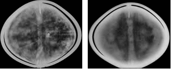
X-radiographs of the the terrestrial and
celestial globes by Rene Gerritsen
OTHER KNOWN EXAMPLES
This set of terrestrial and celestial globes are the same states and comparable to the pairs of globes in the collections of the following museums, although the production number is illegible on some globes (indicated below with a dash).
-Amsterdam, Het Scheepvaartmuseum, inv. no. B 25, Terr.: 3b (‘fabr. no. 7’), Cel.: 2 (‘fabr. no. 4’)
- Rotterdam, Maritiem Museum, inv. nos. M475 and M473, Terr.: 3b (‘fabr. no. -’) Cel.: (‘fabr. no. 4’)
- Greenwich, National Maritime Museum, inv. no. GLB0083, Terr.: 3b (‘fabr. no. 23’) Cel.: 2 (‘ fabr. no. -’) Idem, inv. nos. GLB0152 and GLB0151, (‘fabr. no. 1’) Terr. 3b (‘fabr. no. 1’) Cel.: 2 (‘fabr. no. 2’)
- Brussels, Koninklijke Bibliotheek Albert I, inv. no. IV 10189, Terr.: 3b (‘fabr. no. -’) Cel.: 2 (‘fabr. no. XXIII’)
- Dresden, Staatliche Kunstsammlungen, MathematischPhysikalischer Salon, inv. no. E I 34 (formerly Halle, Hematmuseum), Terr.: 3b (‘fabr. no.-’) Cel.: -
REFERENCES
- Dekker, E., Globes at Greenwich: a Catalogue of the Globes and Armillary Spheres in the National Maritime Museum, Greenwich, Oxford & Greenwich 1999, pp. 278-285.
- Krogt, P. van der, Globi Neerlandici: the Production of Globes in the Low Countries, Utrecht 1993, pp. 501-505.
- Krogt, P. van der, Old Globes in the Netherlands, Utrecht 1984, pp. 58-60.
- Ibidem, pp. 4 and 6 (2).
- Pelletier, M., Cartographie de la France et du monde de la Renaissance au siècle des Lumières, Paris 2001.
- Pelletier, M., ‘Les Globes dans les collections françaises aux XVIIe et XVIIIe siècles’, in ibidem, pp. 30-44
- Stevenson, E.L., Terrestrial and Celestial Globes, 2 vols., New Haven 1921, vol. 2, pp. 27-30.